
High-quality input data drives accuracy in renewable energy forecasting
The quality of the input data provided to a state-of-the-art forecasting method for renewable energy is a key factor for forecast accuracy. One part is static plant information, such as the location and physical plant characteristics. The other part is time-variant data, which comprises – depending on the forecasting method – numerical weather prediction models, weather actuals, satellite images, meter data or information about the current or future status of the plant. In this blog post, we explain the different types of input data, and how high quality of this input data can be assured.
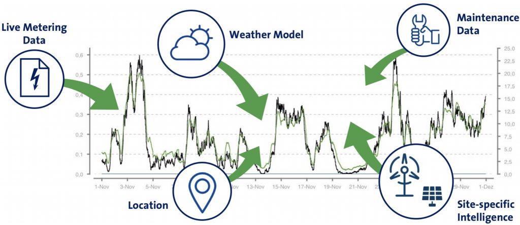
Ingredients for an accurate forecast: Weather models, location and site-specific intelligence are enhanced with maintenance data and live metering data in order to achieve the best forecast quality for each horizon.
Static plant information
Knowing the location of the plant is a prerequisite for setting up a forecast. This can lead to the first quality issues, as the exact geographical coordinates are not always known. And the better the forecasting system knows the physical characteristics and the environment of the plant, the more accurate forecasts it can produce. For this reason, also the manufacturer and model of the turbine or panel, and the hub height (wind) or tilt and orientation (solar) are important data.
Even though plant master data is generally managed in electronic databases, it is not guaranteed that the data that is required for forecast creation is entered into the forecasting system without errors. In some cases, even original data in the user’s business systems does not properly reflect the physical properties of the asset. The reason for this is that the data transmission process is not standardized, interfaces and file formats vary, and it often involves manual steps, even down to the original recording of the data during plant construction. Some of the data critical for accurate forecasting may not be relevant for the core business process of the customer and hence may not be managed in a systematic way.
This leads to frequent problems with plant master data, such as invalid geocoordinates (e.g. wrong format or coordinates that do not match the address) or wrong capacities (due to ambiguous number formats). Supplying a complete data set helps to apply smart master data cleansing, as many mistakes can already be figured out automatically.
Numerical weather prediction models
Numerical weather prediction models are the most important time-variant input for renewables forecasts. High-quality numerical weather prediction (NWP) models are developed and operated by meteorological services to provide weather forecasts to governmental institutions, private organizations and the general public. For a grid of geographical coordinates, they compute the atmospherical conditions for the next hours and days. The NWP models are typically updated at least twice daily, sometimes even every 3 hours.
There are global weather models from a number of meteorological services. Some models, such as NOAA GFS, are available free of charge, but offer limited spatial and temporal resolution. High-resolution models such as ECMWF HRES provide higher quality forecasts.
These global weather models are complemented by regional weather models, covering sometimes only small areas such as single countries, but with a higher spatial resolution and often better suitable to depict local weather phenomena.
Live meter and availability data
Live meter data, but also live availability data, comprising updates about the plant status, maintenance and curtailments, is an important input for short-term forecasts.
When live performance data is systematically fed into the forecasting system and considered in the forecast calculation, this is called a real-time forecast. The maximum delay for real-time integration should be 1 hour, as the forecast error of real-time forecasting methods rapidly increases with increasing time distance between the last available meter data and the forecasted time interval.
Satellite data
Weather satellites offer frequently updated, high-resolution weather data measurements. The most frequently used input data from satellite feeds is solar irradiation. As these weather satellites cover large regions, providing a source of site-specific live data in addition or as an alternative to live meter data.
Read our Whitepaper to learn more
Are you interested how best practices help compute the optimal forecast out of this input data? Read our White Paper: Accurate Power Forecasts for Variable Renewable Energy Using enercast e³ Technology to learn how forecast accuracy can be increased and balancing costs minimized.
enercast GmbH
Universitätsplatz 12
34127 Kassel
Germany
T +49 (5 61) 4 73 96 64-0
F +49 (5 61) 4 73 96 64-99
E info@enercast.de